The PH Weather and Earthquakes app is your comprehensive source for Philippine weather and seismic information. Leveraging data from PAGASA's Project NOAH and PHIVOLCS, it delivers up-to-the-minute weather forecasts, earthquake alerts, tsunami warnings, and volcanic activity updates. This robust application goes beyond local updates, incorporating a global earthquake list from the U.S.G.S. Furthermore, it provides invaluable monitoring tools such as Doppler radar, sensor data (stream gauge, rain gauge, tide level, and weather station readings), and detailed hazard maps. Users also benefit from integrated emergency tools (flashlight, compass) and a directory of critical facilities. Features include hourly and weekly weather forecasts, a moon phase calendar, and integration with PHIVOLCS Fault Finder and LAVA. Suggest features? Visit their Facebook page! Download the app today for enhanced preparedness.
Key Features of the PH Weather and Earthquakes App:
- Weather Information: Real-time weather updates from PAGASA's Project NOAH, including 4-hour and 4-day forecasts, and crucial cyclone tracking information.
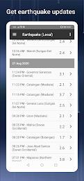
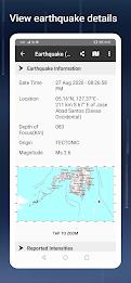
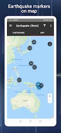
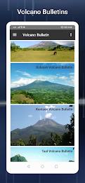
- Seismic & Volcanic Activity: Stay informed about earthquakes, tsunamis, and volcanic eruptions via PHIVOLCS data, ensuring timely alerts and safety measures.
- Monitoring Capabilities: Access a suite of monitoring tools, including Doppler radar, various sensor readings, providing comprehensive environmental data.
- Hazard Mapping: Utilize detailed hazard maps highlighting flood, landslide, and storm surge risks for informed decision-making.
- Emergency Toolkit: Be prepared with integrated emergency tools such as a flashlight, strobe light, siren, and compass.
- Bonus Features: Benefit from additional features including MT Satellite imagery, Ovitrap (dengue) reports, government Twitter feeds, critical facility listings, and a moon phase calendar.
In Summary:
The PH Weather and Earthquakes app provides a vital service, combining real-time weather updates, earthquake warnings, and volcanic activity monitoring. Its integrated monitoring tools, hazard maps, and emergency features empower users to stay informed and prepared for various weather events and natural disasters. Download the app now and enhance your safety and preparedness.